

The Buckeye state was the bull’s eye for a small earthquake recently. On August 27th at 10:43 pm, a magnitude 3.6 earthquake shook the region near Lake Erie in Ohio. This incident marked the third and most substantial earthquake in just a week, a frequency unusual for this area. While Ohio generally ranks low in terms of earthquake potential within the United States, this recent series of events has captured attention.
Despite the origin point being over 300 miles away we detected the earthquake at the Nurture Nature Center with our seismometer. The seismometer is a tool that is used by geologists to detect and measure seismic activity or vibrations moving through the Earth. Although the tremor’s impact was sufficient to jolt cameras and startle individuals across Ohio, its effects were too subtle to be perceptible in Easton. Nevertheless, our sophisticated seismometer picked up on these minute disturbances, resulting in the creation of the seismogram image below.
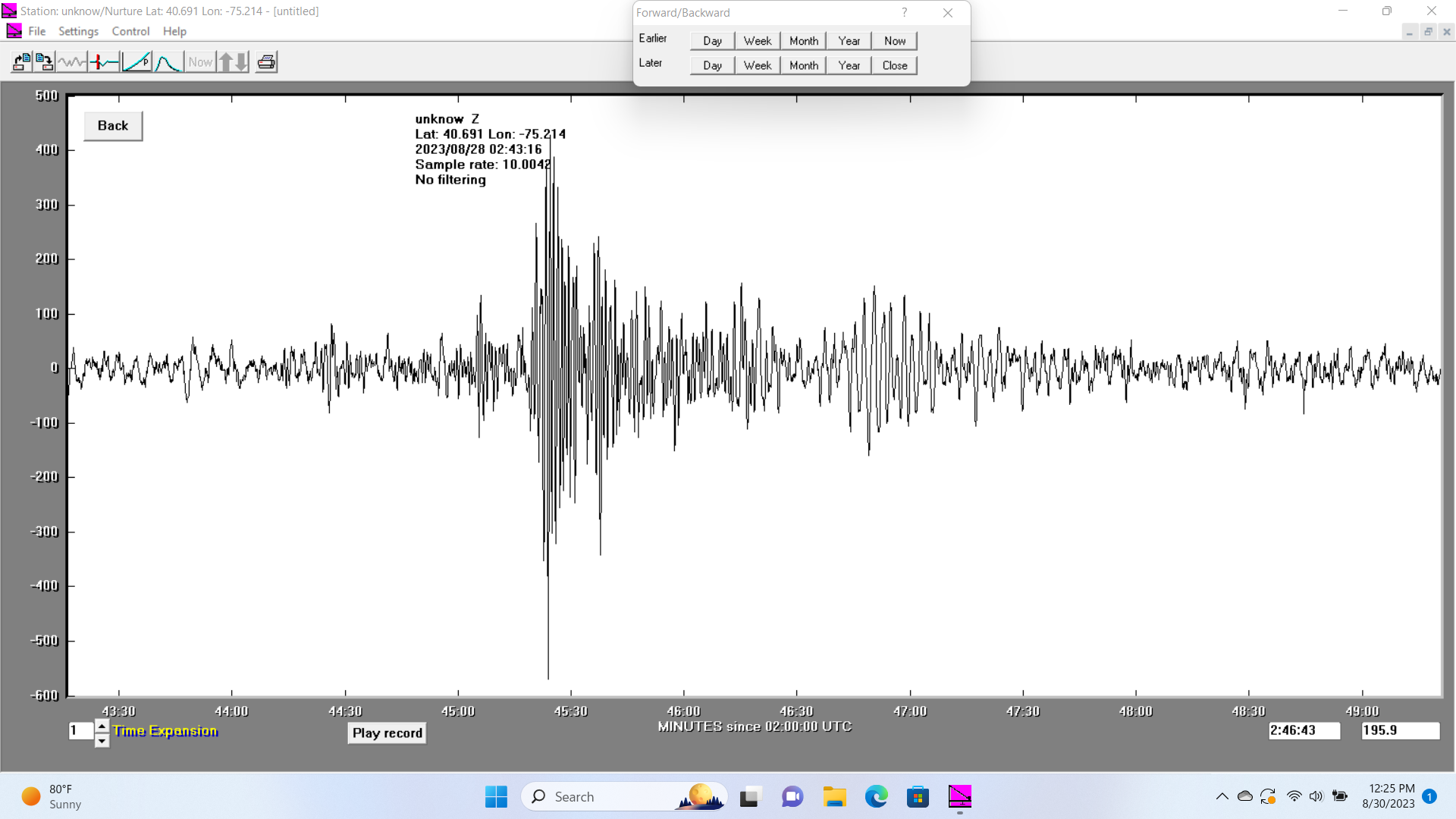
The output from our seismometer that shows the recent earthquake activity.
Although Ohio rarely experiences earthquakes, other parts of the world and the US experience them very frequently. The west coast states of California, Washington and Oregon as well as Alaska experience minor earthquakes every day. They experience major earthquakes less often than minor ones but still at a rate about 100 times greater than on the east coast.
Beneath the Earth’s surface lies a mosaic of moving pieces called tectonic plates, some of which span entire continents. Earthquakes tend to manifest more frequently at the edges of these plates, where they either collide or slide against one another along faults. The east coast is not near the edge of any plate boundaries which explains why earthquakes are so rare there. Millions of years ago, however it was near the edge of an active plate boundary. The edges of the plates in our area produced faults that were active in the past. They are no longer considered active but these ancient faults can still occasionally produce earthquakes.
An instance of significant seismic activity occurred on August 23, 2011, when a 5.8 magnitude earthquake rocked Virginia. The epicenter was located in Louisa County, near the state’s center. This event marked the most powerful earthquake in the northeast US since the 1944 quake of 5.8 magnitude near the New York-Ontario border. The 2011 tremor inflicted structural damage over a wide expanse, encompassing even Washington D.C. Astonishingly, its impact extended to virtually the entire Atlantic coast. This expansive reach sets it apart from similar tremors on the west coast, where the propagation of such effects is notably more contained. East coast earthquakes can be felt over an area 10 times larger than an equivalent earthquake on the west coast. This is due to differences in our geology. Our geology may make earthquakes less likely, but the older colder rocks of our area transmit the energy far and wide like the ringing of a giant bell. Consequently, the Virginia quake reverberated as far south as Georgia and as far north as New England. Notably, around a third of the US population reportedly experienced this quake, solidifying its status as the most widely felt earthquake in US history. It’s plausible that a significant portion of the readers of this article may recall feeling its tremors.
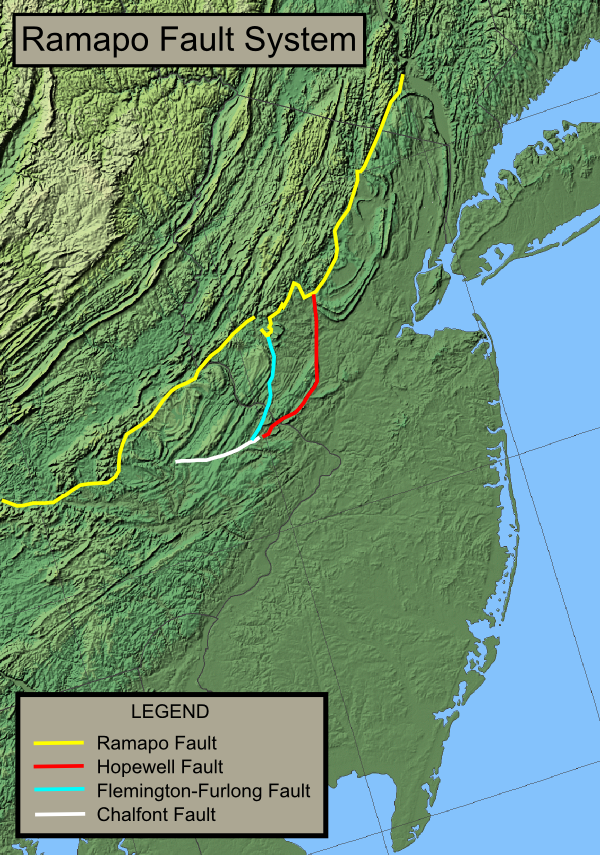
Several fault lines on the eastern coast warrant attention due to their potential implications. The Ramapo fault, in particular, garners concern. Despite remaining dormant for approximately 100 million years, the latent threat of an earthquake lingers. The Ramapo fault lies just a few miles south of Easton and it runs from Haverstraw, New York through central New Jersey and down to Schaefferstown, Pennsylvania. Some seismologists postulate that the Ramapo fault possesses the capacity to generate substantial, damaging earthquakes, with repercussions for the densely populated northeast corridor, including New York City. Others have noted that this particular fault does not have a history of producing earthquakes any more than dozens of other inactive ancient faults in the northeast. Additional information is essential for a comprehensive assessment of the risk posed by this fault. A more profound understanding of seismology as a whole is instrumental in forecasting potential future seismic events.

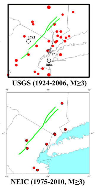
Alan kafka, CC0, via Wikimedia Commons
These images show that there is not a particularly strong correlation between the Ramapo fault and past seismic activity in the area. The red dots are the earthquake locations over the past years and the green line is the Ramapo fault line.
Here is a link to an article with more information: https://en.wikipedia.org/wiki/Ramapo_Fault
Here is a link to an article about the Ohio quake: https://fox8.com/news/did-you-feel-that-earthquake-confirmed-in-ne-ohio/